Drilling Funds Follow Lost 5324 g/t Gold Assay From NZ Mine
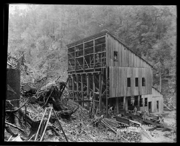
Perth, Sep 6, 2016 AEST (ABN Newswire) - ASX listed Strategic Elements ( ASX:SOR) will fund multiple drill holes beneath a forgotten high grade gold mine on the South Island of New Zealand, where last underground exploration intersected a vein grading 663.8 g/t over 0.75m across the full width of the quartz, including a select sample of 5324.5 g/t over 0.25m. A subsidiary of the Company has just been granted a Minerals Exploration Permit giving it the exclusive right to explore the area for gold for an initial period of 5 years.
Triggering its interest in the area, the Company discovered an extensive set of records on the Aorangi Mine in the depths of Wellington Archives. These include previously unknown underground exploration assays of 663.8 g/t gold including 5324.5 g/t from a sample of selected specimens. Importantly, underground exploration also reported gold mineralisation continuing beneath the old mine.
Managing Director Mr Charles Murphy said "The memory technology project we are backing remains our priority focus, however we raised the capital to drill at Golden Blocks some years ago and have patiently waited until the gold price rebounded to progress to the next stage of permits. The recent capital we raised is earmarked for our technology investments, however we do have capital available to back our exploration projects further. We will ultimately look for larger partners to take them over at the right valuation".
"With interest in gold growing we have received a number approaches for the Golden Blocks project. However, Aorangi was a high grade, narrow vein gold mine where the gold was free milling. These types of projects are rare, especially those that have no modern exploration at all. If you are not willing to follow through with the initial drilling of something like Aorangi in this gold climate, you should roll over and take some other kind of job".
Company Exploration
The Company has previously under its Prospecting Permit mapped sections of the Golden Blocks area, located an extensive number of old workings, confirmed historical records and conducted sampling where access allowed.
The newly granted Exploration Permit enables the Company to conduct drilling for the purpose of identifying mineral deposits or occurrences and evaluating the feasibility of Golden Blocks. An Access Agreement will be sought from the Department of Conservation (the landowner) and resource consents from the Tasman District Council so drilling can be completed.
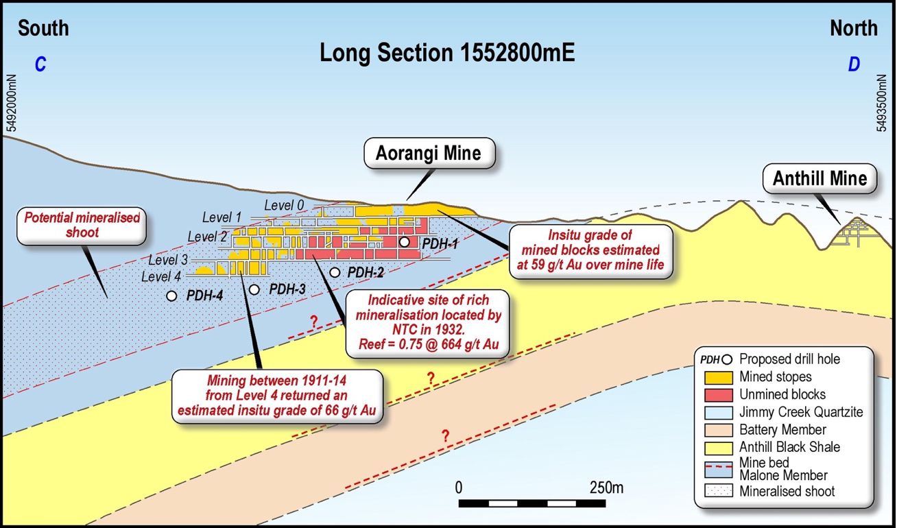
Four conceptual drill targets have been proposed to test below and down plunge of the historic workings as shown in Figure 1 (see link below). These holes are intended as an initial round of drilling with further drilling to occur based on data received.
With reference to Figure 1:
- PDH 1 is located near No.3 Level to intersect the unmined mineralised blocks shown in red.
- PDH 2 is located 125m down plunge to the south from PDH 1 and 25 metres below Level 3. This hole will test for the continuation between the Level 3 and potential bottom of the mineralised shoot.
- PDH 3 is located a further 125m down plunge and will test the mineralisation between Level 4 and the potential bottom of the mineralised shoot.
- PDH 4 is located a further 125m down plunge and will test in the middle of the proposed mineralised shoot 50m down plunge from the historic Aorangi Mine.
The Company has recently conducted orientation soil lines south of the Aorangi Mine successfully confirming modern soil sampling methods as an effective exploration technique in this terrain. Although not targeted at Aorangi, these soil samples still showed anomalous gold along strike (Figure 2, see link below).
The success of the orientation soil lines has justified a more extensive soil sampling program to test for gold extensions both north and south of the Aorangi mine workings. This soil sampling program is expected to commence shortly.
Records of Underground Exploration in 1931
Previously, accepted public record was that no attempt had been made to re-open the mine since it closed in 1914. However, over 1000 pages of archived records discovered by the Company included a little known effort to re-open the goldfield in 1932 by local company New Taitapu Gold Prospecting Company Ltd (NTC).
NTC re-established the mine with 750m of crosscuts and levels re-conditioned and rails laid and the examination of over 1,800m of development work. A prospecting rise was developed in an ore block between No.3 and No. 2 levels with exceptionally high grade ore at the point marked on Figure 1. The reef at this point was 0.75m thick grading 663.8 g/t.
Over the central 25cm of the reef, it was reported that the quartz was thickly impregnated with coarse gold and assayed 5,324g/t. The No.4 Level was flooded and was not entered.
Importantly, the stone around the shoot was also said to be "exceptionally good". An extensive effort was made to validate the NTC results, with the Company successfully tracking the actual laboratory assay sheets from this underground work to the Thames School of Mines, now a mining museum in Thames, New Zealand.
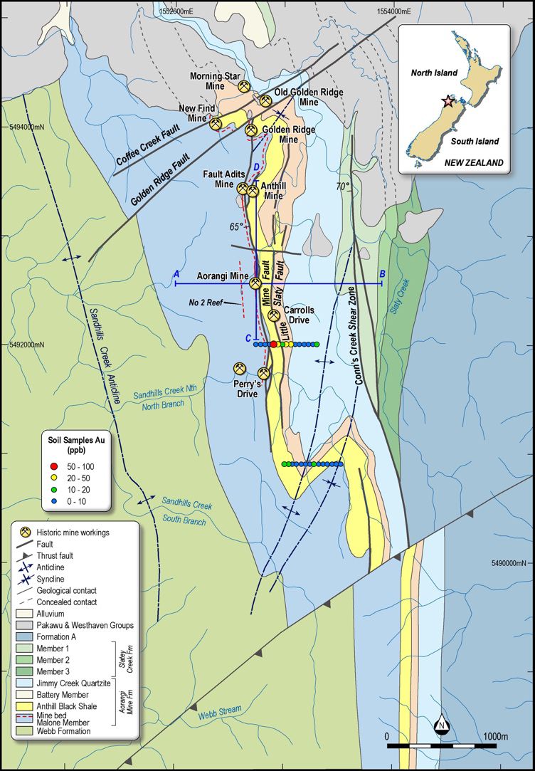
Prospecting by NTC in the area around the mine resulted in the discovery of a reef (No 1 Reef) located around 100m to the east of the Aorangi Mine (Figure 3, see link below). This reef strikes N-S for 500m and dips 45DEG to the west parallel to the Aorangi mine reef. The reef thickness varies from 1 to 6m. Sampling has proved the reef is gold bearing and further opening up is justified on the evidence already obtained.
Archived records contained in the Wellington Archives also increase support for gold mineralisation to extend beneath the previously mined levels. Exploration in 1932 by NTC successfully tested for gold beneath No. 3 Level by sinking into the floor of the unmined level. They reported, "gold showing" in their workings.
Unfortunately, despite their success, the financial environment of the time cruelled NTC's efforts to re-open the mine. For unknown reasons, records of their successful work were not lodged with the NZ government mining system. The land was eventually leased out for forestry until it was purchased by the crown in 1985.
Reports
Archived records also included a 1933 independent report from highly distinguished New Zealand geologist Dr James Park, a former Director of the Thames School of Mines, "From what I know of the past history of this mine and the undoubted favourable geological conditions there is, in my opinion, warrant for the belief that valuable ore shoots may be looked for in the deeper ground".
Archived records also included a 1932 report from T.O. Bishop, former government Inspector of Mines, who inspected the mine multiple times in his official capacity. "I am of the opinion that the strength and continuity of the reef in the upper workings entirely justifies the expectation of it living to greater depths". He also confirmed that the last level mined (No. 4 Level), was accessed from No. 3 level and that "high grade ore was disclosed in both the shaft and the level".
The Golden Blocks Project
The project comprises a number of historic mines located at the contact between shale and sandstone lithology's with 85% of the gold production derived from a sheared shale unit called the Mine Bed.
The Mine Bed appears to extend approximately 2.5km and was intermittently mined at Perry's Drive, Aorangi, Fault Adits, Golden Ridge and the New Find mines (Figure 2).
To the north the Aorangi Mine Formation is unconformally overlain by relatively thin Cretaceous sediments and the Aorangi Mine Formation extends for at least another 3kms further to the south.
The geology of the area is correlative with the Greenland Group of Westland which is the host for the economically extremely important Reefton Goldfield which produced over 2Moz of gold. The lithological content and structural style for both areas are very similar and fossils from the Aorangi Mine area and from near Reefton are of the same age and where effectively separated by the intrusion of the Karamea Batholith during Devonian times.
Other parallel mineralised reefs lie on the contact between the Anthill Black Shale and Battery Member (Carrolls Drive and Reef No. 1 an unmined reef east of the Aorangi Mine) and between the Battery Member and the Jimmy Creek Quartzite (Morning Star and Old Golden Ridge mines).
The No 2 reef identified in the Golden Blocks Mine Prospectus lies approximately 200m to the west of the Mine Bed near the Aorangi Mine and lines up with a historic mine in Sandhills Creek (Figure 2).
Total gold production was 46koz with an average recovered grade of 36 g/t with the largest Aorangi mine producing 26koz between 1898 and 1914 when the mine closed due to shortages of labour with the outbreak of war. During the mine life 21kt of ore was processed and returned 27koz for an average recovered grade of 38.5g/t. Recovery was estimated at 65% indicating an insitu grade of 59.2g/t for the ore processed.
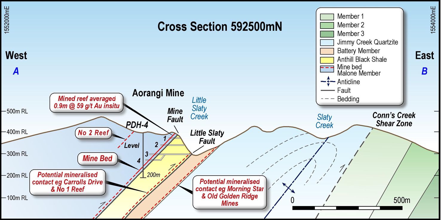
The Mine Bed at the Aorangi was mined over 4 levels down to 130 metres below the surface (Figure 1). The reef was strong and well defined throughout the workings and had been developed for length of around 400m along the north-south strike.
The reef average around 1m thick and dipped ~45DEG to the west with a shallow 20DEG south plunge to the mineralised shoot. As shown in Figure 1, the vertical extent of the mineralised shoot is estimated at 150m based on the top and bottom of the stopped (gold) and unstopped blocks (red).
Importantly, the potential exists for other mineralised shoots along strike to the north and south.
The reef consists of a series of lenticular quartz veins continuously connected and mined along 400m and was considered to have considerable vertical and lateral extensions (Bell 1907).
In 1911 an inclined 5m by 5m shaft was sunk 30m from No 3 Level to No 4 level. The reef extended across the width of the shaft (0.30m thick on the south side and 0.75m on the north side) with 200oz's recovered during the shaft development.
From the bottom of the shaft the Level 4 drive has been driven approximately 110m. Production records from Level 4 between 1911 to 1914 when the mine closed indicted the insitu grade of the ore processed was 66g/t based on a recovery of 65%. Records show that the reef continues in the faces both to the north and south where the mine closed.
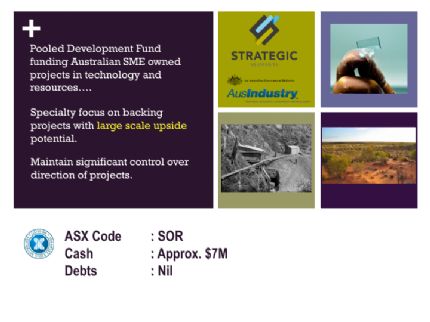
ASX Listed Strategic Elements Ltd
The Company has a special registration from the Federal Government as a Pooled Development Fund enabling eligible shareholders to pay no capital gains tax when they sell their shares in ASX listed Strategic Elements (ASX:SOR). In return the Company must back only Australian SME's.
To view tables and figures, please visit:
http://abnnewswire.net/lnk/7NR0716L
About Strategic Elements Ltd
 Strategic Elements (ASX:SOR) shares are listed on the Australian Stock Exchange under the code “SOR”. The Company is registered under the Pooled Development Program run by the Australian Federal Government to encourage investment into SME’s. To assist Pooled Development Fund’s to invest and raise capital, the Federal Government enables most shareholders in a Pooled Development Fund to make capital gains and receive dividends tax-free.
![]()
| ||
|