Quarterly Activities and Cashflow Reports
Perth, Oct 29, 2015 AEST (ABN Newswire) - Pacifico Minerals Ltd ( ASX:PMY) is pleased to provide its activities report for the September 2015 quarter.
Highlights
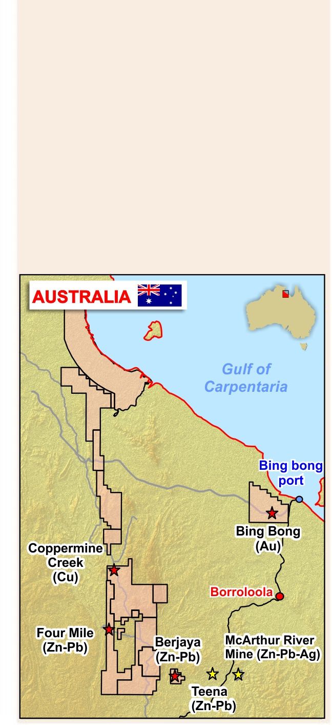
AUSTRALIA
Borroloola West Project, NT - Copper/Zinc/Lead/Silver/Manganese
- Drilling intersects significant intervals of disseminated chalcopyrite and bands of semimassive chalcopyrite at Coppermine Creek indicating that Pacifico may have drilled the fringe of a major copper mineralised system.
- Results received from the three hole programme include:
o CCD03 10m @ 1.3% Cu from 68m, including 2m @ 4.0% Cu
o CCR01 16m @ 0.5% Cu from 43m
o CCD02 23m @ 0.3% Cu from 136m
- Higher grades are contained in semi-massive chalcopyrite lenses, with very little associated pyrite, and with textures very similar to those at the world class Mount Isa copper deposit.
- Pacifico earns 51% interest in Borroloola West Project from Sandfire Resources NL ("Sandfire") and is subsequently able to earn up to an 80% interest.
- Subsequent to quarter end drill testing commenced on the airborne electromagnetic ("AEM") high conductivity bullseye anomaly 2km south of the prior drilling.
- Subsequent to the quarter end field geological mapping and reconnaissance sampling defined an outstanding zinc-lead prospect at Four Mile with potential for relatively shallow McArthur River style mineralisation.
COLOMBIA
Berrio Project - Gold
- High grade mineralisation confirmed underground at Berrio
- Underground channel sampling grades include multiple >1oz per tonne assays.
- Latest results strongly support Pacifico's exploration strategy along the faulted Contact between the Berrio Sediment Package and Segovia Batholith.
- One artisanal mine sampled representing only a fraction of the mineralised structure within Pacifico's tenements.
CORPORATE & FUNDING
- Pacifico exhibited at Diggers and Dealers mining forum.
- Consolidated cash balance at 30 September 2015 was approximately $2.0 million. The Company has no debt.
- Subsequent to the quarter end Pacifico raised $500,000 through a placement to institutional and sophisticated investors.
Australia
Borroloola West Project, Northern Territory - Copper/Zinc/Lead/Silver/Manganese
The Borroloola West Project ("Borroloola") is a large exploration project (granted licence area of ~2,500km2) situated in East Arnhem Land of the Northern Territory, 600 km southeast of Darwin and comprises 15 exploration licences, one mining licence and one exploration licence application. Pacifico is earning up to 80% from Sandfire Resources NL under a farm-in agreement through staged exploration. The project area is underlain by the Neoproterozoic McArthur Basin, the northern extension of the Mt Isa Basin and host to several world-class SEDEX deposits including the Western Fold Belt copper deposits at Mt Isa and the HYC zinc/lead/silver deposits currently being mined at the McArthur River mine just 30km east of the project tenements.
During September Pacifico announced that it has completed expenditure of $1.5 million at the Borroloola West Project, thereby earning the right to acquire a 51% interest from Sandfire Resources NL ("Sandfire") (ASX:SFR). Pacifico has provided notice to Sandfire to this effect, and under the terms of the farm-in agreement may (within 60 days) elect to continue sole funding exploration into the second earn-in period with the objective of earning a 70% interest through expenditure of a further $2.5 million over 2 years. Pacifico is subsequently able to earn up to an 80% interest in the Borroloola West Project.
Subsequent to the quarter end Pacifico announced it had commenced drilling at the AEM bullseye at Coppermine Creek. This exciting drilling program is ongoing.
Coppermine Creek (copper)
Coppermine Creek is situated 100km north-west of the McArthur River zinc-lead-silver mine. The mineralised Gordons Fault is seen as outcropping gossans with malachite staining over a strike length of at least 900m. Reverse circulation ("RC") and diamond drilling had previously only been undertaken at the eastern extremity and produced results including 30m @ 1.1% Cu in RC hole GPR07 and 34m @ 0.5% Cu in RC hole GPR091. The 700m strike extent of the mineralised fault to the west was completely untested by drilling.
During the quarter, Pacifico announced very encouraging visual results from its 3 hole drilling program at the Coppermine Creek Prospect (see ASX announcement 13 July 2015 for further details). Drill core demonstrated that the Gordons Fault zone contains broad zones of brecciation and dolomite-silica alteration of siltstones with both disseminated chalcopyrite and bands of semi-massive chalcopyrite. Stratabound disseminated chalcopyrite away from the fault was also recognised, associated with a dolomitised ex-evaporite unit.
During August Pacifico announced assay and interpretation results for the drilling program (see ASX announcement 6 August 2015 for further details). Results confirmed that drilling intersected extensive zones of intense fracturing containing disseminations and lenses of semi-massive chalcopyrite. All three drill holes intersected copper mineralisation and confirmed the strike continuity of the east-west trending Gordons Fault.
The first drillhole, CCR01, drilled reverse circulation ("RC"), intersected oxidised copper mineralisation in the hangingwall of the fault from 29m, grading 42m at 0.3% Cu (Table 1 in link below) with highest values of 5m at 0.8% Cu from 49m. Host rocks are Amelia Dolomite containing zones of intense fracturing, brecciation and dolomitisation. The hole had to be abandoned before entering the Gordons fault zone because of collapsing ground.
CCD02 was drilled 104m reverse circulation ("RC") and then diamond drilled to 315m. It intersected a significant interval of disseminated and veinlet chalcopyrite associated with a 10m thick bed of ex-evaporite, containing closely packed dolomitised gypsum casts, and contained 23m at 0.3% Cu from 136m, including 5m of 0.8%Cu from 147m.
Minor disseminated chalcopyrite was also present throughout a zone of intense fracturing, brecciation and dolomitisation between 242m and 286m. It is interpreted that the Gordons Fault mineralisation is cut off by the later Coppermine Creek Fault in this hole.
CCD03 (diamond drilling only) also intersected copper mineralisation associated with this same ex-evaporite bed with an intersection of 16m at 0.3% Cu from 40m, including 3m of 0.8% Cu from 40m. It then passed through the Gordons Fault zone with lenses of semi-massive chalcopyrite, as well as chalcopyrite fracture fill and disseminations, and contained 5m of 2.5% Cu from 68m, including 2m at 4.0% Cu from 71m.
The mineralisation and alteration, which contains disseminated sulphide comprising dominantly chalcopyrite, is reflected in AEM conductivity profiles that indicate a broad zone of alteration and disseminated mineralisation that extends for 3km x 1km, south from the Gordons Fault. Our 3D geological model, built up from studies of previous drilling information, comprises gently dipping, bedding replacement, stratabound copper mineralisation lying in the upper part of an alteration zone in Amelia Dolomite and Mallapunyah Formation sediments, beneath 200m to 250m of flat lying dolomitic siltstones.
Within this alteration zone there is a well defined 1000m x 300m bullseye of relatively high AEM conductivity that lies 2km south of Gordons Fault and Pacifico's recent drill holes. This may reflect more intense chalcopyrite stockwork veining and lenses at depths from 250m to over 600m. Gossanous material overlying the western part of the bullseye AEM anomaly, in overlying Tooganinie Formation sediments, contains up to 0.3% Cu (from qualitative portable X-Ray Fluorescence instrument ("pXRF") determinations) and confirms the presence of copper mineralisation in this area.
A diamond drill hole was designed to intersect the AEM conductivity high and was subsequently begun in the following Quarter.
Supporting the opportunity for the presence of a major copper mineralised system of the Mount Isa Copper (approximately 250Mt of 3% Cu) or Nifty (approximately 100Mt of 2% Cu) style are the following key geological factors:
- Distinctive ex-evaporite beds in the overlying Amelia Dolomite contain disseminated copper mineralisation.
- The mineralisation lies close to the redox contact between hematitic siltstones (oxidised) of the Mallapunyah Formation, and the overlying Amelia Dolomite.
- Reverse faulting at Coppermine Creek indicates that copper mineralisation could be related to a compressive regional event.
- The copper mineralisation appears to be spatially related to a major north-south trending regional fault system that may provide access to copper-bearing basin fluids.
- Intense fracturing, brecciation and dolomite (- silica) alteration is widespread and related to the copper mineralisation.
- Coppermine Creek lies within the McArthur Basin, where there are known large base metal mineralised systems, in an area that has only been patchily explored previously.
Bing Bong (copper-gold)
During the quarter Pacifico also completed its two-hole drill program at the Bing Bong prospect. Two diamond holes were drilled to 400m and 300m respectively, with 100m RC (reverse circulation) pre-collars. A thick sediment package belonging to the Roper Group was intersected with no significant mineralisation. Any intrusive present, as previously interpreted, may be considerably deeper. The core has been delivered to the NTGS as part of cofunding conditions where the NT Government will refund 50% of the direct drilling costs.
Four Mile (zinc-lead-silver)
At Four Mile recent geological mapping (figure 6) has identified poorly outcropping Barney Creek Formation (host to the mineralisation at the McArthur River zinc-lead-silver mine) with a possible strike length of over 14km.
Selected rock chips of outcrop are consistently high in lead within the Barney Creek Formation package of sediments. Small pods of gossan in the Barney Creek Formation sediments contain up 0.26% Pb (A.L.S. laboratory analysis), which is a highly positive indication in this very weathered terrane for significant zinc - lead mineralisation. A versatile time domain electromagnetics ("VTEM") survey was conducted previously by Pacifico over part of the area. There are clear targets to test the Barney Creek Formation for relatively shallow zinc - lead mineralisation, with RC and diamond drilling. One of the diamond drill targets is shown in figure 7, over a VTEM anomaly.
Berjaya (zinc-lead-silver)
The Berjaya EL lies about 30km west of the McArthur River Mine, Australia's largest zinc-lead-silver producer, and one of the largest zinc-lead-silver deposits in the world, with a total deposit size of 227Mt of 13.4% Zn + Pb3. Also Rox Resources Ltd's recently discovered Teena Deposit (exploration target of 60 - 80Mt of 8 - 12% Zn + Pb4) lies about 18km west of Pacifico's Berjaya tenement.
The Berjaya tenement contains the Barney Creek Formation package, and major growth faults, key geological components at both the McArthur River mine and the Teena deposit.
The Barney Creek Formation package within the Berjaya tenement has been intersected in previous drilling by Mount Isa Mines Ltd, and recognised in mapping by Pacifico. A major north-east trending growth fault is indicated by Pacifico's geological mapping, and confirmed by the VTEM survey (see Figures 5, 6 and 7). Also of interest is a kilometre long zone of dolomite brecciation within the Mara Dolomite Member, which has a highly ferruginous breccia matrix. To the north of this zone sedimentary breccias are interbedded with dolomitic siltstone.
The rocks on the Berjaya tenement are all extremely highly weathered, making previous conventional stream sediment and soil sampling programmes of limited effectiveness. Direct surface chip sampling over the silcretised and leached rocks is also difficult.
Figures 9 and 10 show a VTEM Resistivity Depth Images ("RDI") sections and interpretation. Conductive zones in the VTEM correspond to the down dip extent of weathered beds observed at surface that contain abundant disseminated boxworks after sulphides, and are indicative of the prospective stratigraphic package, of which the potentially mineralised Barney Creek Formation is a part.
It is planned to drill test for zinc-lead-silver mineralisation, targeting the base metal prospective Barney Creek Formation close to major growth faults.
Borroloola West Project - other prospects
The Borroloola West Project covers an outstanding package of ground running for over 200km north-north-west of the McArthur River Mine - the world's largest zinc - lead producing mine. Potential for the discovery of world class sized base metal deposits in this region is high. The comparable Mount Isa Basin of Queensland contains several major copper and zinc - lead deposits in an area of similar geology and structure.
Recently identified prospects include:
Johnstons (copper)
Irregular faulting and fracturing with copper and lead mineralisation. It lies in an area of poor outcrop and will require RC drilling to explore for extensions.
Tawallah Pocket (copper)
Widespread copper mineralisation is found close to the Amelia Dolomite / Mallapunyah Formation contact. It is comparable to the geology at Coppermine Creek and requires further geological mapping to establish mineralisation controls.
Colombia
Berrio Project - Gold
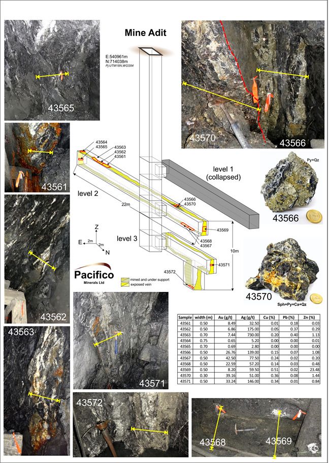
The Berrio Gold Project is situated in the southern part of the prolific Segovia Gold Belt and is characterised by a number of artisanal-scale adits. The project is 35km from the Magdalena River which is navigable to the Caribbean Sea and has excellent infrastructure in place including hydro power, water supply, sealed roads and telecommunications coverage.
During the quarter Pacifico announced highly encouraging results from the latest channel sampling program at the Berrio Gold Project (see ASX announcement 9 July 2015 for further details). 11 channel samples from artisanal workings were taken at various intervals covering 22m of contact strike. Of importance is the fact that these artisanal workings only occupy a small fraction of the 14km mineralised structure mapped at the Berrio Gold Project.
Previous exploration by Pacifico and results from this latest channel sampling program indicate that mineralisation continues along the contact 20m below surface and remains open at depth as well as to the north and south. Highgrade gold and silver mineralisation hosted at the contact between the Berrio Sediment Package and Segovia Batholith included:
- 50cm @ 42.49 g/t Au, 77.5 g/t Ag and 0.24% Cu (channel sample 43567)
- 50cm @ 33.24 g/t Au, 146 g/t Ag, 0.34% Cu and 0.84% Zn (43571)
- 80cm @ 31.41 g/t Au, 106 g/t Ag and 0.23% Cu (composite channel sample 43566 and 43570)
- 50cm @ 8.19 g/t Au, 59.5 g/t Ag, 0.5% Cu and 23.48% Zn (43569)
Channel sampling was undertaken across two levels and was restricted to faces and pillars left by miners to act as support in stopes (see Figure 1). Previous field mapping, selective grab and soil sampling undertaken by Pacifico identified gold anomalism associated with the contact between the Berrio Sediments and Segovia Batholith which is the primary target at the Berrio Gold Project.
Conceptually, the block channel sampled by Pacifico, measuring 22m x 20m and, based on 11 channel samples, has a weighted average width of 0.59m and weighted average grade of 15.50 g/t Au, 147.14 g/t Ag, 0.16% Cu and 2.26% Zn.
See Table 1 below for all 11 channel sample results. Further exploration along the contact is warranted and these channel sample results strongly support Pacifico's exploration strategy along the faulted contact between the Berrio Sediments and Segovia Batholith.
Pacifico is exploring for high-grade gold mineralisation, with associated silver and base metals, hosted at the faulted contact between the Berrio Sediments and the Segovia Batholith, the contact has been mapped within Pacifico's tenements for 6.2km and is projected to continue for a further 7.8km (see ASX announcement 18 February 2015 for further details).
Recent soil sampling across the contact identified several well developed gold anomalies closely associated with the mapped contact with one of these anomalies extending for well over 1km along the contact (see ASX announcement 25 June 2015 for further details).
Previous IP surveys conducted by Pacifico provide partial coverage across the mapped contact in one of the areas where soil sampling was undertaken (see ASX announcement 3 July 2014 for further details). Highly encouraging well developed resistivity lows and chargeability highs are noted at the contact underlying the gold in soil anomaly.
Ongoing and future exploration plans
Additional soil sampling is ongoing to the east of the central grid to target shear hosted mineralisation in the Berrio Sediments, a style similar to that drilled by Pacifico in its 2014 campaigns. Soil sampling has proven to be a cost effective and efficient method for guiding exploration at Berrio and we look forward to testing the remaining 11km of the faulted contact mapped within our tenement package.
Underground channel sampling of artisanal mines close to the contact will continue. Pacifico expects to report further soil sampling and underground channel sampling results during November 2015.
Guided by gold in soil anomalies and the latest results from underground channel sampling Pacifico's geologists are currently designing drill program to test the continuity of high-grade mineralisation at the contact along strike and down dip of artisanal mines.
Natagaima Prospect - Copper/Silver/Gold
The Natagaima tenement application is situated in the department of Tolima, approximately 5km west of the navigable Magdalena River which drains into the Caribbean Sea. It is located within the Middle Cauca Porphyry Belt.
Follow up exploration will continue only once the Natagaima tenement application is granted to Pacifico. Follow up exploration will include detailed mapping and trenching of areas of interest.
Mount Jukes Project, Tasmania - Copper/Gold/Base Metals
The Mt Jukes Project is adjacent to the Vedanta owned Mt Lyell copper/gold project in Tasmania. Corona Minerals Ltd ("Corona") is the operator and manager of this project. Further details about the project can be found on Corona's website www.coronaminerals.com.
Springfield Project, New South Wales - Gold
The Springfield Project is centred between Gulgong and Mudgee, 220km northwest of Sydney. Pacifico is awaiting notice of future exploration programs proposed by its joint venture partner, Stonewall Resources Ltd ("Stonewall"). Further details about the project can be found on Stonewall's website www.stonewallresources.com.
Corporate & funding
During the quarter, Pacifico exhibited at this year's Diggers and Dealers mining forum in Kalgoorlie, Western Australia. The consolidated cash balance at 30 September 2015 was approximately $2.0 million. The Company has no debt.
Subsequent to the quarter end, Pacifico raised $500,000 via a placement to institutional and sophisticated investors. Investors subscribed for 50 million common shares, at 0.1c per share, to raise $500,000 before costs. The Placement was undertaken within the Company's available capacity under the ASX Listing Rules. Settlement, placement and allotment occurred 15th October 2015. Funds raised will be used to accelerate exploration at the highly prospective Borroloola West Project in NT, Australia where drilling has recently commenced at the very exciting Coppermine Creek copper prospect.
To view all tables and figures, please visit:
http://media.abnnewswire.net/media/en/docs/ASX-PMY-739669.pdf
About Pacifico Minerals Ltd
 Pacifico Minerals Ltd (ASX:PMY) is a Western Australian based exploration company focussed on advancing the Berrio Gold Project located in Colombia. Berrio is situated in the southern part of the prolific Segovia Gold Belt and is characterised by a number of operational, artisanal-scale adits, tunnels, and declines. The project is 35km from the Magdalena River which is navigable to the Caribbean Sea and has excellent infrastructure in place including hydro power, sealed roads, water supply and telecommunications coverage. Pacifico also has an interest in two other projects in Colombia (Natagaima and Urrao) and one project in the NT, Australia (Borroloola West Project).
![]()
| ||
|